Table of Contents
Buying or selling a home in Hawai‘i means looking beyond views, square footage, and neighborhood feel. Flood zones, lava zones, and coastal erosion maps shape insurance requirements, monthly costs, lender decisions, and the strength of an offer. These designations are not abstract. They show up in disclosures, underwriting, and long-term ownership expenses.
At Hawai‘i Modern Realty we walk clients through these maps every week. Here is what the risk layers mean and how they influence real transactions across the islands.
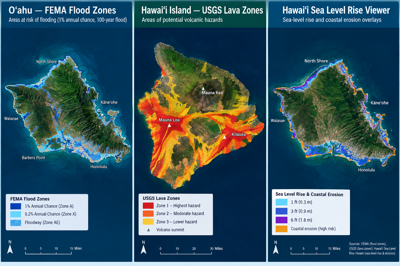
Flood Zones and the 2026 O‘ahu Map Update
FEMA Flood Insurance Rate Maps (FIRMs) classify properties by flood risk. Special Flood Hazard Areas (zones A, AE, AH, AO, V, VE) carry a 1 percent or greater annual chance of flooding. Zone X is lower risk. Zone D means the area has not been fully studied.
On June 10, 2026, updated FIRMs took effect for the City and County of Honolulu. The revision redrew zones along roughly 100 miles of streams and moved about 3,500 parcels into Special Flood Hazard Areas for the first time. Neighborhoods in Lā‘ie, Kāne‘ohe, Wai‘anae, East Honolulu, and parts of the North Shore saw the largest shifts.
If a property has a federally backed mortgage and sits in a Special Flood Hazard Area, the lender requires flood insurance. Standard homeowners policies exclude flood damage. Coverage comes through the National Flood Insurance Program or private carriers. Premiums reflect elevation, foundation type, distance to water, construction, and claims history. Newly mapped properties may qualify for a Newly Mapped discount if a policy is purchased within the first year after the effective date. That discount can reach 70 percent on the initial coverage limits and then phases out.
Even properties in Zone X can flood. Heavy rain, stream overflow, and runoff move quickly on the islands. Roughly 40 percent of flood claims nationwide come from outside high-risk zones. Many O‘ahu residents outside mapped Special Flood Hazard Areas have reported flooding. Insurance remains voluntary in lower-risk areas, yet it is often worth evaluating.
Flood insurance carries a 30-day waiting period under the NFIP. Timing matters if a map change or purchase is approaching.
Lava Zones on Hawai‘i Island
The U.S. Geological Survey divides Hawai‘i Island into nine lava-flow hazard zones. Zone 1 carries the highest long-term probability of coverage by lava. Zone 9 carries the lowest. The map, last substantially revised in 1992, remains the reference for long-term hazard. It reflects eruption history, vent locations, and topography rather than short-term activity.
Zones 1 and 2, which include parts of lower Puna and areas near active rift zones of Kīlauea and Mauna Loa, present the steepest practical challenges. Most private carriers do not write standard homeowners policies there. Coverage often comes through the Hawai‘i Property Insurance Association (HPIA), the state’s residual market, or specialty markets such as Lloyd’s. Premiums are higher and coverage limits can be capped. FHA financing is generally unavailable in Zones 1 and 2. Conventional lenders also apply tighter standards. Cash or portfolio lenders become more common.
Zones 3 and higher typically support broader insurance availability and more conventional financing. Property values often reflect the risk differential: land and homes in higher-risk zones trade at lower prices than comparable properties farther from the active systems.
Lava risk is not limited to insurance. It affects the resale pool, lender appetite, and the total cost of ownership. Buyers who understand the zone before writing an offer avoid surprises later.
Coastal Erosion and Sea-Level Rise Exposure
Coastal properties face another layer: chronic erosion and projected sea-level rise. The State of Hawai‘i Sea Level Rise Viewer and related shoreline studies map exposure areas that combine passive flooding, annual high-wave flooding, and coastal erosion under different sea-level scenarios, including the widely referenced 3.2-foot rise.
Hawai‘i law requires sellers to disclose whether a residential property falls within the 3.2-foot Sea Level Rise Exposure Area. This disclosure is separate from FEMA flood zones. Erosion can affect foundations, setbacks, and long-term usability even when a structure currently sits outside a Special Flood Hazard Area. Studies have observed measurable price effects for properties with elevated exposure to flooding and erosion relative to similar unexposed homes.
Insurance does not automatically solve erosion risk. Flood policies address inundation; chronic shoreline retreat is a different exposure. Buyers of oceanfront or near-shore property should review historical shoreline change data, current setbacks, and projected hazard zones alongside the flood map.
How These Maps Shape Insurance, Offers, and Negotiations
Risk designations influence four practical areas:
Insurance cost and availability. Flood insurance is mandatory for federally backed loans in Special Flood Hazard Areas. Lava Zones 1 and 2 limit carrier options and raise premiums. Coastal exposure can affect underwriting even when flood insurance is not required.
Financing. Lenders require proof of coverage where mandated. Some products are unavailable in the highest lava-risk zones. Force-placed policies are more expensive if an owner does not obtain coverage in time.
Offer strength and contingencies. Informed buyers factor estimated insurance into their monthly payment calculations. Sellers of newly mapped or higher-risk properties may see fewer offers or requests for credits. Early disclosure of known map changes can prevent last-minute surprises.
Resale and long-term value. Properties with clearer risk profiles and manageable insurance often attract a broader buyer pool. Cash buyers sometimes gain an edge in constrained financing markets.
A practical comparison of common impacts:
Risk Layer | Primary Islands | Insurance Effect | Financing Note | Buyer/Seller Impact |
|---|---|---|---|---|
FEMA SFHA (A, AE, V, etc.) | All, especially O‘ahu after 2026 update | Mandatory for most mortgages; NFIP or private | Lender requires policy | Higher monthly cost; possible Newly Mapped discount |
Zone X / lower risk | All | Optional but recommended | Usually no mandate | Still evaluate actual drainage and history |
Lava Zones 1–2 | Hawai‘i Island | Limited carriers; higher premiums; possible caps | FHA generally unavailable; tighter conventional | Smaller buyer pool; cash advantage |
Lava Zones 3–9 | Hawai‘i Island | Broader availability | Standard options more common | More conventional market dynamics |
Coastal erosion / SLR-XA | All coastal | Disclosure required; may affect underwriting | Review setbacks and projections | Long-term value and habitability considerations |
How We Approach Risk Maps at Hawai‘i Modern Realty
We treat risk maps as decision tools, not deal-breakers. Our advisors pull the current FEMA map, lava zone designation where relevant, and sea-level-rise exposure data early in the process. We help buyers estimate realistic insurance costs before they write an offer and help sellers prepare clear disclosures so transactions move smoothly.
Local knowledge matters. Stream behavior on O‘ahu, drainage patterns in specific neighborhoods, and the practical difference between lava zones on Hawai‘i Island are details that do not appear in a generic listing description. We combine that on-the-ground understanding with modern search and analysis tools so clients see the full picture.
Areas We Serve and Property Types We Know Well
We work across the islands with focused experience in:
O‘ahu neighborhoods from Kailua and Kāne‘ohe to Kapolei, ‘Ewa, Honolulu, and the North Shore
Condos, townhomes, and single-family homes
Luxury and oceanfront properties
Investment and rental properties
New construction and open-house opportunities
Relocation and first-time buyer guidance
Whether the property sits near a stream, on the coast, or on Hawai‘i Island lava terrain, we help you read the maps and the market together.
Useful Tool for Buyers and Sellers
Before you finalize an offer or list a property, run the numbers on monthly costs. Our mortgage calculator lets you model principal, interest, taxes, and estimated insurance so you can see how a flood or higher lava-zone premium changes the payment. Pair it with a conversation about actual quotes from insurers familiar with Hawai‘i risk layers.
Frequently Asked Questions
Do I need flood insurance if my property is in Zone X?
No federal mandate usually applies, yet flooding still occurs outside Special Flood Hazard Areas. Many owners choose coverage based on actual drainage, elevation, and local history.
What changed with the O‘ahu flood maps in 2026?
Updated FIRMs became effective June 10, 2026, and moved roughly 3,500 parcels into higher-risk zones. Newly mapped properties with federally backed mortgages generally require flood insurance and may qualify for a temporary Newly Mapped discount.
Can I get a conventional loan in Lava Zone 1 or 2?
Options are limited. FHA is generally unavailable. Many conventional lenders apply stricter standards or decline. Cash or specialized portfolio financing is more common.
Does coastal erosion affect insurance the same way flood zones do?
Not exactly. Flood insurance addresses inundation. Erosion and sea-level-rise exposure trigger seller disclosure requirements and can influence long-term value and underwriting, but they are separate layers.
Should sellers disclose a new flood-zone designation before the effective date?
Early disclosure of known changes can reduce transaction friction. Once maps are effective, the designation becomes part of the official record that lenders and buyers will review.
How do these risks affect my offer strategy?
Build realistic insurance estimates into your payment analysis. On the sell side, clear documentation and proactive answers to risk questions help keep the process on track.
Ready to Review Risk Maps with a Local Advisor?
Risk maps are part of the Hawai‘i real estate landscape. Understanding them early protects your budget and strengthens your position as a buyer or seller. If you are evaluating a specific property or preparing to list, reach out to a Hawai‘i Modern Realty advisor. We will pull the relevant maps, walk through the insurance implications, and help you move forward with clear information.